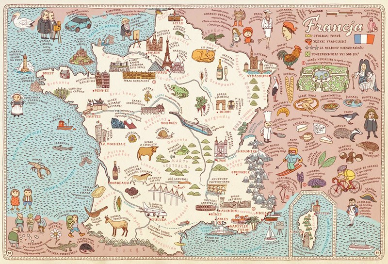
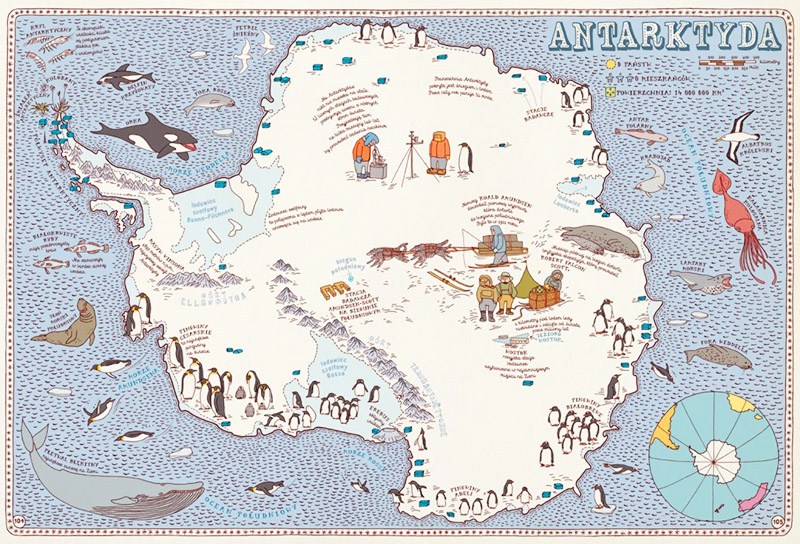
Imaginary journeys have never been so real. The Mizielińskis didn’t present yet another collection of diagrams taken out of geography textbooks. Their maps look as they are yellowed by time, dirty papyruses found in a box in the attic. Just like pirate maps, they hide treasures. Each of the 51 images is a magical journey through lands, seas, and oceans. The duo of guides draws a route through all continents, showing a close-up of most interesting countries.
Aleksandra Mizielińska and Daniel Mizieliński, Maps, Wydawnictwo Dwie Siostry, source: Instytut Książki / www.instytutksiazki.pl
Information is given out gradually. The first map shows the globe, and the next one presents Europe with the outlined contours of its and capitals. Others show detailed images of chosen countries. Similarly, we get to know other continents. In place of a legend we have the most important facts about each country: the name of the capital, official languages, the number of inhabitants and the country’s size. Giving the original name of a country is also a great idea – readers can work on their language skills. The symbolical ending is a collection of flags. What’s most captivating though are the miniatures of people, animals, and dishes which thoroughly reflect the reality of these countries. Through these illustrations we get to know customs, the most important species of flora and fauna, characteristic buildings, and elements of the landscape. We can observe Arctic icebergs and Egyptian pyramids, we taste Indian curries, listen to Mexican mariachis, smell Dutch tulips, and feel the rhythm of Brazilian samba. Maps can be experienced through all one's senses.
This mass of information can be overwhelming at the beginning, and the book's chaotic composition only reinforces the feeling of being lost. Travelling around mysterious corners of our planet has a lot of charm, however. Wandering in this labyrinth of information consolidates facts for the reader or sometimes even lets them discover something new. The protagonists of the greatest fables, writers, artists and kings help young readers to find their way.
Aleksandra Mizielińska and Daniel Mizieliński, Maps, Wydawnictwo Dwie Siostry, source: Instytut Książki / www.instytutksiazki.pl
The duo of Polish illustrators spent three years realizing the project. The fruit of these long journeys through places known and unknown is the few thousand illustrations which fill the maps of 42 countries. This knowledge, accessible to everyone, was translated by the authors into a symbolic, visual language. They’ve proven that with a few sketches and no unnecessary words, one can show the spirit of a nation, the customs of its inhabitants, and its heritage. The symbolic, colourful, detailed illustrations, reminiscent of children's drawings, are a great replacement for monotonous descriptions taken out of an encyclopedia. Texts, concise and meaningful, are also abundant, though. The names of plants and animals, regional products and customs were written in specially the designed fonts Mrs White and Cartographer. The letters created by Mizielińscy are an element of the image, and echo the forgotten art of calligraphy.
While the idea of creating an atlas for children was not very original, the way it was realized is delightful. The first edition of the book was sold out in a month. In France, Maps won the prestigious Prix Sorcieres 2013 from the society of booksellers, and ‘The New York Times’ listed the book among the most beautiful albums for children in 2013. What’s most important though is the recognition of millions of readers in more than 20 countries where Maps has been published.
The Mizielińskis took a huge step in the history of cartography and climbed the Everest of human fantasy. They help people learn, giving them lessons in geography, history, zoology, botany and culture. Most of all they also ‘smuggled’ into their work the great values of tolerance, passion and family. And that’s how they put themselves on the map of world literaturę for children.
Author: Agnieszka Warnke, August 2015, transl. N. Mętrak-Ruda, December 2015.
