The Map Is Not the Territory: How Satirists Charted Poland When It Wasn't on the Map
In the late 18th century, Poland disappeared from the political map of Europe and didn’t return until over a century later. But is the map the territory? Where was Poland when it wasn’t there? Culture.pl tries to find Poland in the maps of cartographers and satirists who were suddenly dealing with a missing country that never truly went away.
In 1795, the last of a series of partitions effectively wiped Poland off the map of Europe. Naturally the country and its citizens didn't vanish altogether, and the so-called 'Polish question' was an important element of debate in 19th-century Europe. Here’s how cartographers and cartoonists reflected on the position of Poland at a time when the country was relegated from the map... Namely, the Polish question illustrated.
Before the partitions
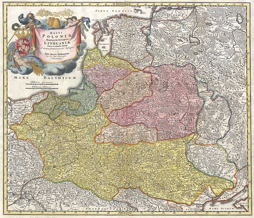 An 18th-century map of the Kingdom of Poland and the Grand Duchy of Lithuania, one of the greatest empires in Europe, source: Polona.pl
The Partitions of Poland came in the late 18th century. But beforehand in the 16-17th centuries, the Polish-Lithuanian Commonwealth was one of the most powerful empires in Europe. At the peak of its power in the late 17th century this multi-ethnic state stretched from the Baltic to the Black Sea. The map above shows the empire in the 18th century, not long before it was disbanded.
Cutting the cake
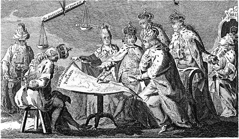 Picture of Europe for July 1772 - an anonymous British print, source: British Museum
The first partition of Poland took place in July 1772. For many of its contemporaries, the seemingly legal partition of an existing legal state must have seemed like a hardly paralleled event in history. A contemporary British satirical drawing titled Picture of Europe in July 1772 shows an allegorical picture of the first partition of Poland, with the three monarchs – Katherine the Great, Joseph II and Frederick the Great – dividing Poland in the presence of Polish king Stanislaus August, pictured here as their captive.
The two monarchs shown in the background – French king Louis XV and Charles III of Spain – seem to be indifferently assisting the process, while the British king George III is drowsing in the corner. The scale above the head of the Polish king shows a sudden shift in the balance of powers. But the doings of the monarchs turned out only an introduction to more permanent changes in Europe. Over the next 25 years, the map on their laps was re-drawn at least twice more – a process which came to an end in 1795 with the final partition.
And it’s gone...
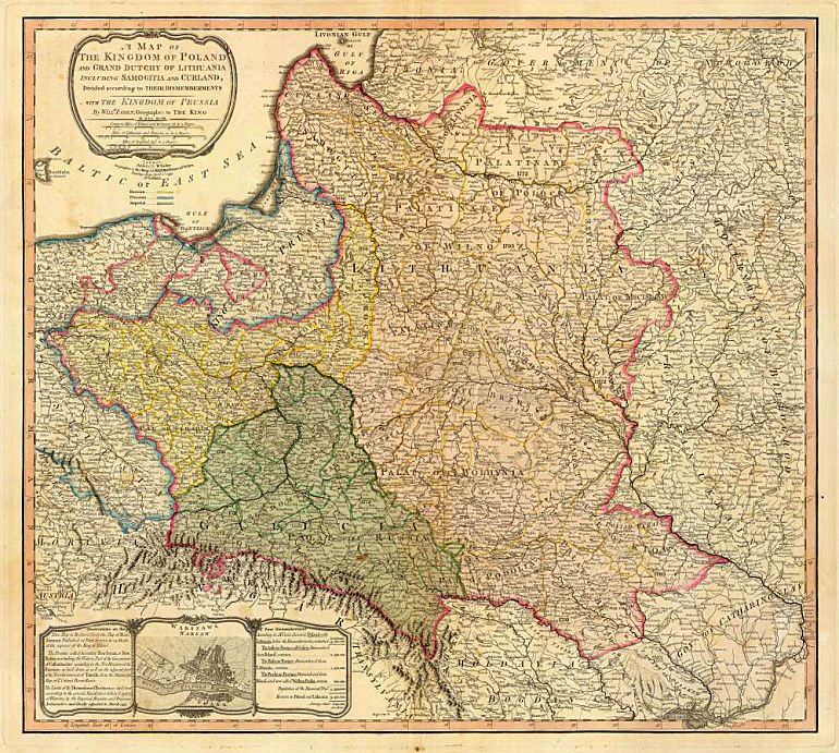 A map of the Kingdom of Poland and the Grand Duchy of Lithuania including Samogitia and Curland divided according to their dismemberments with the Kingdom of Prussia from 1799, source: Wikimedia Commons
This 1799 map by English cartographer William Faden shows the former territories of Poland five years after the last partition. The boundaries of the former Polish-Lithuanian Commonwealth are coloured light red. The map marks the land acquisitions made by Prussia (yellow), Austria (green), and Russia (beige). As a result of the three partitions, the territory of former Poland was divided among Austria (128,900 km2), Prussia (141,400 km2) and Russia which gained most ground (462,000 km2 and 5.5 million people).
Or is it...
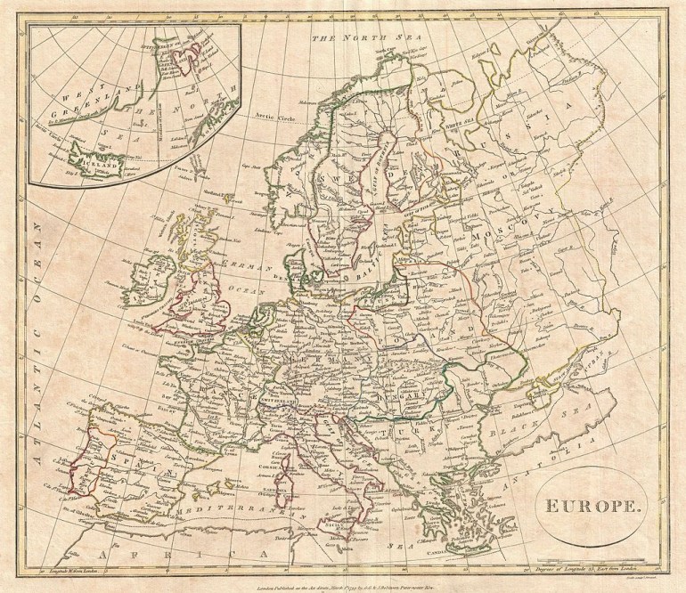 A map of Europe from 1799 by the English map publisher Clement Cruttwell, source: Wikimedia Commons
But let us not lose hope. The name of Poland didn't disappear completely. Here’s an English map from the same year (1799) whose author seems to have missed the partitions. Poland is shown with its traditional borders and one can read Poland standing proudly across the territories.
Poland as nowhere (1870)
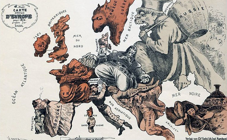 French Carte Drolatique from 1870, source: Berlin State Library, via Europeana
Satirical maps of Europe were a popular way to symbolically reflect the various tensions and sympathies of European politics. This is French map of Europe by Paul Hadol was created shortly before the outbreak of the French-Prussian war of 1871. Poland is not there (it's essentially somewhere under the Prussian soldier's moustache) but notice also that the map doesn’t include countries that were already on the map in 1870, like Greece.
Poland's grave (1870)
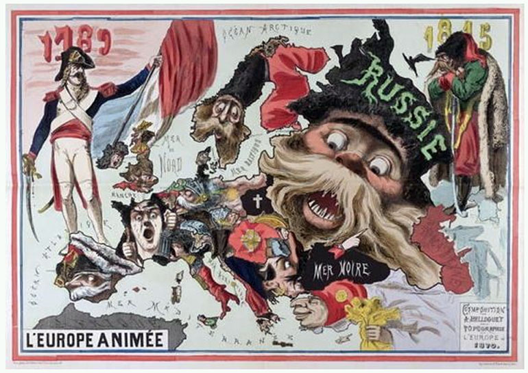 L'Europe Animée, composition de A. Belloguet sur la topographie de l'Europe; Source: Bibliotheque Nationale
Presenting Poland as a grave and its nation as a dead man was a popular way to imagine the fate of a country that was terminated, or to put it more figuratively, 'buried alive'. In fact, this is how many Poles – and especially Polish poets – came to see the fate of their country. Little wonder that Poland's ultimate return on the map of Europe was sometimes described as a ‘resurrection’.
 'A Map of the Disunited States of Europe (Carte des etats desunis d'Europe), a Belgian map from 1864, note: Poland rests in a tomb, Russia is a white bear and Prussia is an octopus. Photo: Wikimedia / National Library of Sweden
Can you find Poland in this picture?
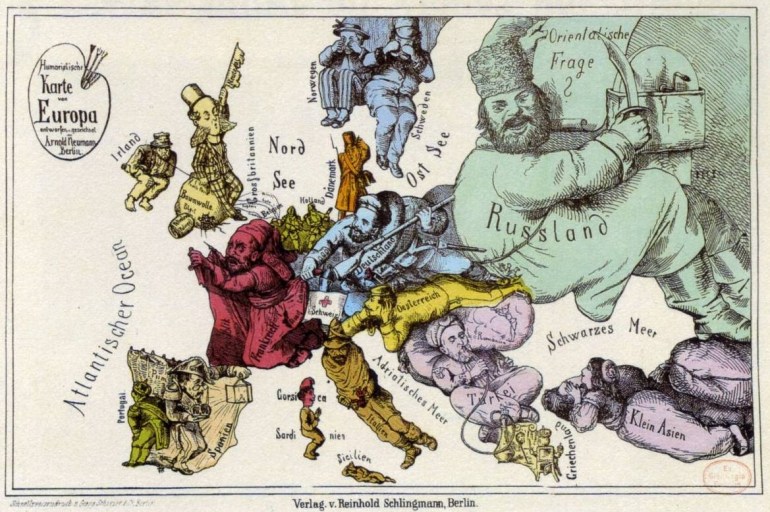 Arnold Neumann's map of Europe from 1870; Source: public domain
Another satirical map, this time German, from the same period shows Russia as a giant ruthless boyar sharpening a huge knife. He is pushing with his back on Germany and Austria. Poland, it might seem at first, is not there. But take a closer look! Can you see a little guy holding onto the belt of the giant and being almost crushed by his backside? With all probablility, it’s Poland.
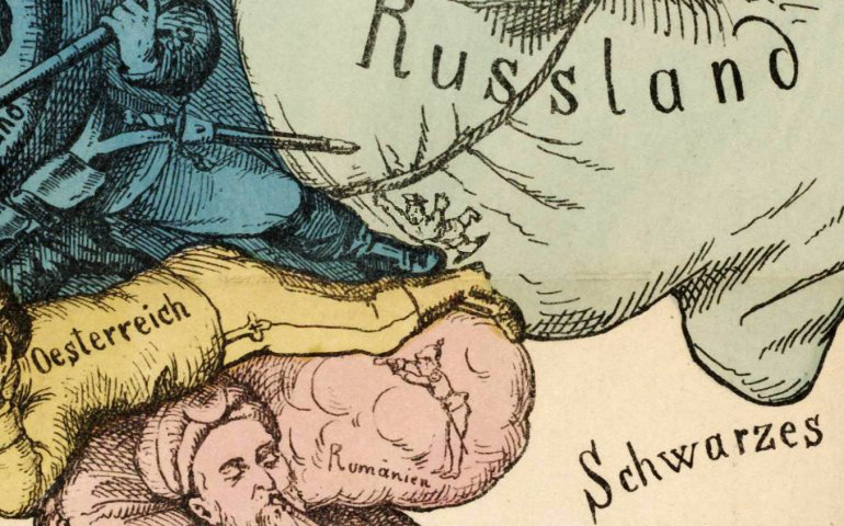 Close-up showing a small man being crushed under Russia from Arnold Neumann's map of Europe from 1870
Polonia shackled
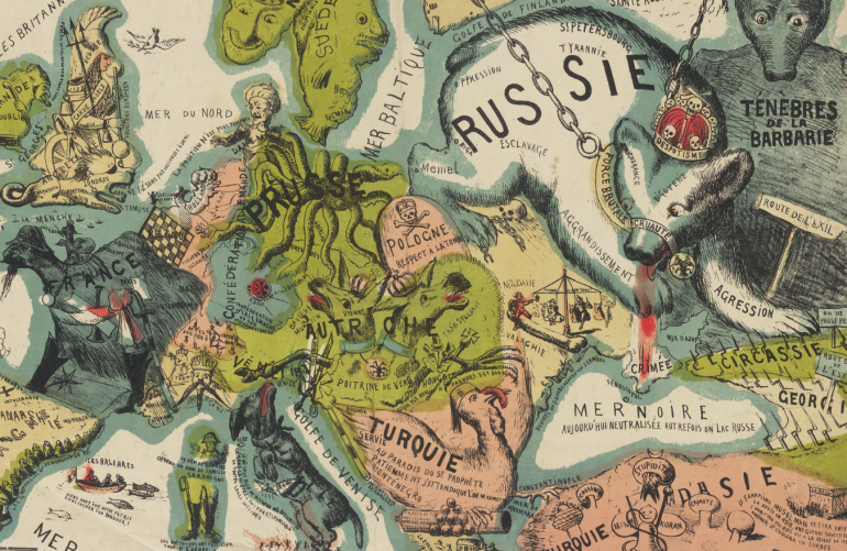
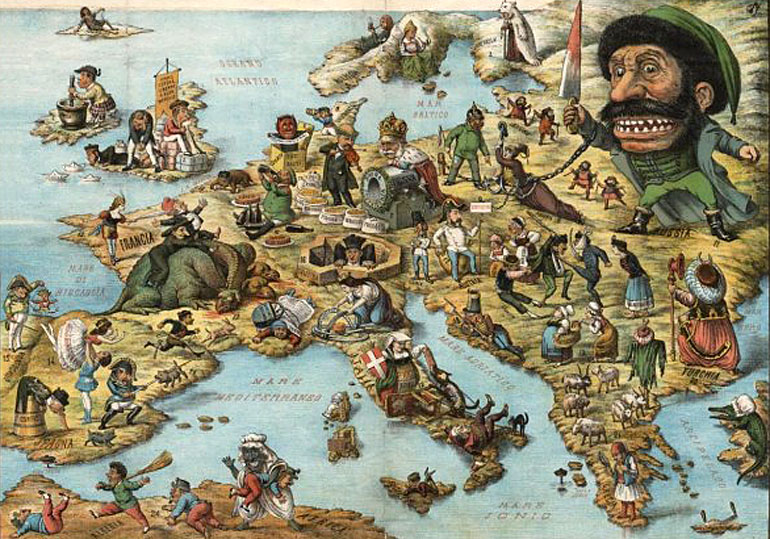 Political comic map of Europe with verse relating to nations, suggests date of 1871, photo: public domain
In this Italian map, published originally in Bologna circa 1871, Poland is shown as a shackled fair lady on the ground, holding on to an anchor (traditionally a symbol of hope). The figure, usually referred to as Polonia, is chained by the iron belt around her waist to three oppressors: Russia again is a giant dwarf holding a knife dripping with blood, while an Austrian soldier and the Prussian Kaiser are considerably smaller. Note the little men at the feet of the Russian Tsar – they are serfs who rejoice after the abolition of serfdom which took place in the Russian Empire in 1861, and in the Polish Kingdom in 1863. The Italian verse (here translated into English) carries a rather sad lesson:
Poland / Tied in shackles, at the feet of her tyrants / The name of Nation honours her no more... / She can't rise up! She can't avenge herself / Who carries like a mule, deserves to be beaten
In the arms of the octopus
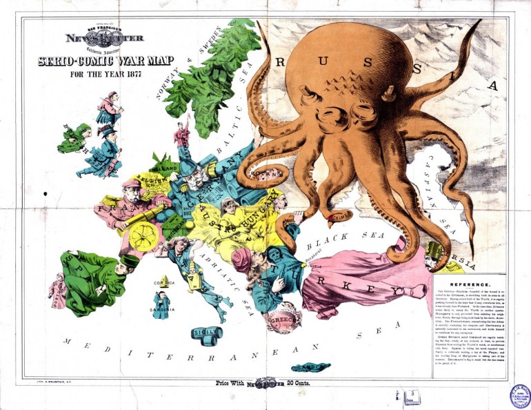 Rose W.F., Serio-Comic War Map For The Year 1877, Great Britain 1877; Photo: public domain
In its time, the regularly-updated British Serio-Comic War Map by Fred Rose was one of the most popular symbolic representations of political tensions in Europe. The map, often referred to simply as the Octopus Map, had many variants which also changed with time to better fit the purposes and political agendas of those who created them.
The original version from 1877 shows Russia as an octopus, and Poland is seen as suffocating in the grasp of one of the octopus’s arms. The other arms are reaching out to different parts of the continent: Germany, Scandinavia and Turkey (which is being surrounded from both directions). And yet, in regard to Poland, this (clearly anti-Russian) depiction somehow forgets to represent also other oppressors. The map below from 1900 reiterates many of these allusions, while also showing the octopus expanding east...
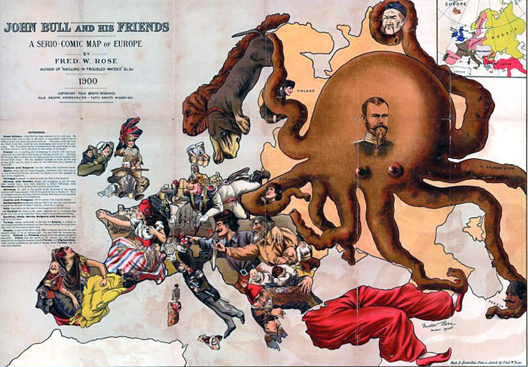 Rose's 1900 edition of his octopus map, Photo: public domain
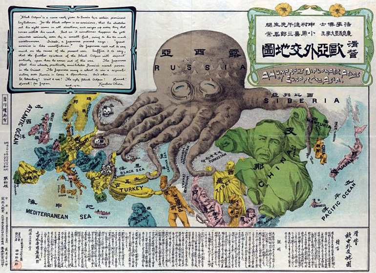
A later Japanese variant of the map shows stylised skulls for Poland and Finland – regions for whom the touch of the octopus was deadly. In this version, the arms of the Russian octopus are reaching to Persia, India, China and even Tibet.
 Kisaburō Ohara Europe and Asia Octopus Map, 1904; Photo: public domain
Why is Poland a bloodhound? (1882)
 The European Animal, a satirical map made by A. Belloquet in 1882, photo: public domain
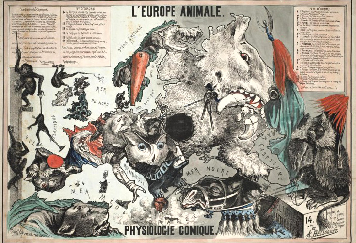
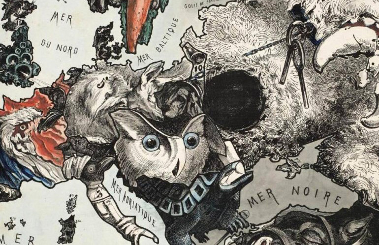
This splendid French satirical map from 1882 shows the European states as animals. Poland is presented as a dog chained to its master Russia, which itself is presented as a white bear munching on a crescent, a symbol of Turkey. The other partitioning powers are presented as a fox (Germany) and an owl (Austria). The legend explains that the fox's head head rests on a friendly Austria but his eyes watch the scenes in France, the owl is explained as the Grand Duke, 'eager and anxious'.
 The European Animal, a satirical map made by A. Belloquet in 1882, photo: public domain
The legend expounds that the Polish dog in the picture is Chien de Saint-Hubert, that is a bloodhound. The dog wears an alarm bell – but its overall symbolism eludes us. Another question is the meaning of the black hole right where Ukraine and Belarus are today...
Printed in Poland... without Poland (1898)
 Heinrich Kiepert Map of Europe from 1898 (8th edition), photo: Polona.pl
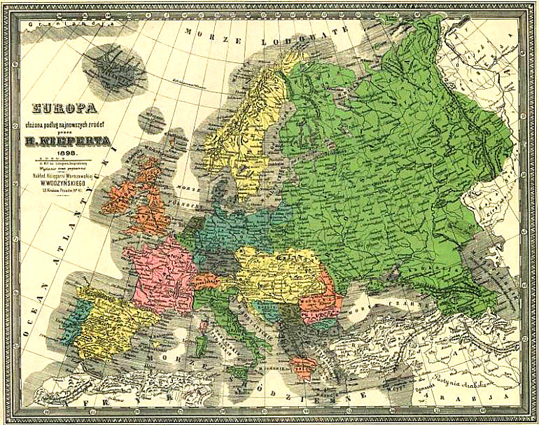
 The political situation at the close of the century looked pretty grim for Poland. This map printed in 1898 in Warsaw, shows no trace of Poland except for the Polish-sounding names of cities and towns. At this time Warsaw was the capital of Privislinsky Krai, a part of the Russian Empire. The Russian Cyrillic note at the bottom left reads 'Dozvoleno cenzuroû Varšava' – a sign of the ubiquitous censorship which was part of the oppressive system in the empire of the Tsar.
The Great War hides Poland (1914)
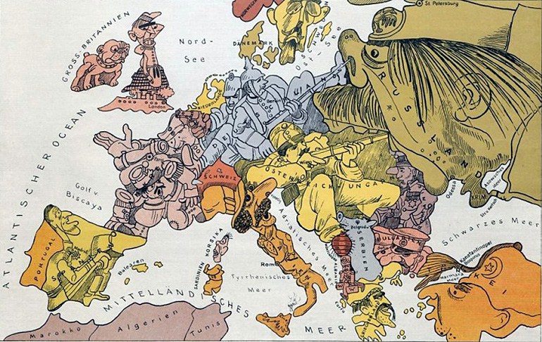 German satirical map of Europe from 1914, photo: Berlin State Library via Europeana
 This German satirical map from 1914 shows the conflicting sides of the Great War. While the picture doesn’t even show Poland, Poles did engage in war fighting on many sides. The result: an independent Polish state that eventually emerged from the next four years of carnage.
Back on the map (1918)
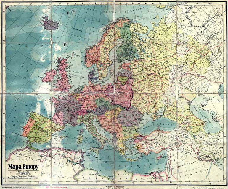 Map of Europe from 1921, published in Lviv, photo: Polona.pl
In 1918, after 123 years of partitions, Poland once again appeared on the map of Europe. The map above shows the new Polish territory in 1921, that is, with the Vilnius and the country's eastern border as the result of the Polish-Russian War of 1920.
The new Europe emerges... and disappears
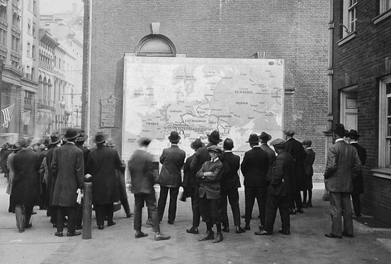 People outside Philadelphia's Independence Hall and 'a new map of Europe showing new nations' in November 1918, photo: Wikipedia
The new map of Europe, as seen being admired in this picture in the US, would only last a little over 20 years . World War II effectively recharted the map of Europe once again in its east.
Author: Mikołaj Gliński, August 2017
Tytuł (nagłówek do zdjęcia)
[{"nid":"5688","uuid":"6aa9e079-0240-4dcb-9929-0d1cf55e03a5","type":"article","langcode":"en","field_event_date":"","title":"Challenges for Polish Prose in the Nineties","field_introduction":"Content: Depict the world, oneself and the form | The Mimetic Challenge: seeking the truth, destroying and creating myths | Seeking the Truth about the World | Destruction of the Heroic Emigrant Myth | Destruction of the Polish Patriot Myth | Destruction of the Flawless Democracy Myth | Creation of Myths | Biographical challenge | Challenges of genre | Summary\r\n","field_summary":"Content: Depict the world, oneself and the form | The Mimetic Challenge: seeking the truth, destroying and creating myths | Seeking the Truth about the World | Destruction of the Heroic Emigrant Myth | Destruction of the Polish Patriot Myth | Destruction of the Flawless Democracy Myth | Creation of Myths | Biographical challenge | Challenges of genre | Summary","topics_data":"a:2:{i:0;a:3:{s:3:\u0022tid\u0022;s:5:\u002259609\u0022;s:4:\u0022name\u0022;s:26:\u0022#language \u0026amp; literature\u0022;s:4:\u0022path\u0022;a:2:{s:5:\u0022alias\u0022;s:27:\u0022\/topics\/language-literature\u0022;s:8:\u0022langcode\u0022;s:2:\u0022en\u0022;}}i:1;a:3:{s:3:\u0022tid\u0022;s:5:\u002259644\u0022;s:4:\u0022name\u0022;s:8:\u0022#culture\u0022;s:4:\u0022path\u0022;a:2:{s:5:\u0022alias\u0022;s:14:\u0022\/topic\/culture\u0022;s:8:\u0022langcode\u0022;s:2:\u0022en\u0022;}}}","field_cover_display":"default","image_title":"","image_alt":"","image_360_auto":"\/sites\/default\/files\/styles\/360_auto\/public\/2018-04\/jozef_mroszczak_forum.jpg?itok=ZsoNNVXJ","image_260_auto":"\/sites\/default\/files\/styles\/260_auto_cover\/public\/2018-04\/jozef_mroszczak_forum.jpg?itok=pLlgriOu","image_560_auto":"\/sites\/default\/files\/styles\/560_auto\/public\/2018-04\/jozef_mroszczak_forum.jpg?itok=0n3ZgoL3","image_860_auto":"\/sites\/default\/files\/styles\/860_auto\/public\/2018-04\/jozef_mroszczak_forum.jpg?itok=ELffe8-z","image_1160_auto":"\/sites\/default\/files\/styles\/1160_auto\/public\/2018-04\/jozef_mroszczak_forum.jpg?itok=XazO3DM5","field_video_media":"","field_media_video_file":"","field_media_video_embed":"","field_gallery_pictures":"","field_duration":"","cover_height":"991","cover_width":"1000","cover_ratio_percent":"99.1","path":"en\/node\/5688","path_node":"\/en\/node\/5688"}]
